The following is a map of the home location of all individual Nobel Peace Prize winners since 1978. Every individual point represents the location of each individual winner, and lines connect the multiple winners of shared prizes (Example: the 1998 Nobel Peace Prize was shared between David Trimble of Northern Ireland and John Hume of Ireland). A polygon is used to denote the area of Norway from which the Norwegian Nobel Committee gives out the various awards. A photo is embedded with the picture of Liu Xiaobo, the 2010 winner of the Nobel Peace Prize from China, and there is an embedded link to a video of President Barack Obama's acceptance speech in 2009.
View Nobel Peace Price Winners by Country since 1978. in a larger map
The entire internet is shifting to a more user-uploaded-content infrastructure. Concepts such as Wikipedia, or Facebook, which thrives off of user-generated content, have boomed in popularity over the past decade. Following the trend of the broader internet, the concept of neogeography can be defined as “…people using and creating their own maps, on their own terms and by combining elements of an existing toolset. Neogeography is about sharing location information with friends and visitors, helping shape context, and conveying understanding through knowledge of place” (Turner 2006).
User-generated content has several advantages. First, it allows people to comment, add, or in this case create maps of those ideals or messages which are closer to ideological set of beliefs. This allows for a staggering size of sheer data uploaded daily, which even corporate entities cannot compete with on a consistent basis. A simple test case can be observed in the race between Google and Microsoft in creating Google Earth. In creating GoogleEarth, Google encouraged user-uploaded content and pictures uploaded to add to their database. Microsoft only uploaded their own content in creating their version of Virtual Earth, and Google clearly won the race in assembling massive quantities of data necessary for this vision.
However, like most user-generated sites, there is some cause for worry with neo-geography. People can very easily only complete maps with either inaccurate data or data that only reflects their personal ideological agendas. To use the above map as a reference case, a Chinese government official could very easily not include Liu Xiaobo in his rendition of the above map and thus give an inaccurate rendering that conveniently fits his worldview.
Neogeography, and user-generated content schemes as a whole, allow for any individual to create massive amounts of content, and fast. The above map took less than an hour to complete. And while this map is truthful and accurate, this new wave of user-generated content is vastly unregulated. Without any authorities, the validity of data is very quickly called into question. The chances are very good that somewhere, someone in China is simply making their own map to reflect their own personal ideology and leaving the latest Nobel Peace Prize winner, quite literally, off the map.
Tuesday, October 12, 2010
Tuesday, October 5, 2010
Lab 2
1. The name of the quadrangle is the Beverly Hills Quadrangle
2. The names of the adjacent quadrangles are : Canoga Park, Van Nuys, Burbank, Topanga, Hollywood, Venice, and Inglewood.
3. The topography was first compiled in 1966, but this particular map was created in 1995.
4.One datum is the North American Datum of 1927 and North American Datum of 1983(horizontal datum) and the second datum is the National Geodetic Vertical Datum of 1929 (vertical datum).
5. The scale of the map is 1:24,000
6.
a. 5 centimeters on the map=5*24,000/100=1,200 meters
b. 5 inches on map=5*24000/(5280*12)=1.89 miles
c. 1 mile on ground=5280*12/24000=2.64 inches on map
d. 3 km on ground=3*1000*100/24000=12.5 cm on map
7. The contour interval is 20 feet, with a supplementary contour interval of 10 feet.
8.
a. Public Affairs Building: 118.44 degrees West, 34.07 degrees North
b. Tip of Santa Monica Pier: 34 degrees North, 118.5 degrees East
c. Upper Franklin Canyon Reservoir: 34.12 degrees West, 118.41 degrees West
9. Elevation in Feet and Meters
a. Greystone Mansion: 580 feet or 177 meters
b. Woodlawn Cemetery: 140 feet or 43 meters
c. Crestwood Hills Park:
10. Universal Transverse Mercator (UTM) Zone 11
11. UTM Coordinates for the lower left corner of the map are (37) 63 Northing, (3) 61.5 Easting
12. 1,000,000 square meters
Monday, October 4, 2010
Lab 1
 This map, graphically displaying the biogeographical distribution of the black rhino population (viewed here), shows the native habitat of black rhinos in sub-Saharan Africa. An interesting facet of this map is how the area demarcating the native population of black rhinos is featured in red, thus insinuating the dire threat facing the black rhino and perhaps even implying its status as an endangered species. Such subtle clues can help to evoke subconscious emotions in the viewer.
This map of California's National Parks can be viewed here. I found this map intriguing as it portrays all of California's National parks, thus celebrating the natural wonders located throughout the state. However, despite California's televised fame with beautiful beaches abounding throughout the entire coast, the only coastal enclave nationally recognized for it's beauty is Channel Islands National Park, with the rest of the state's National Parks located farther inland. Ironically, the map also includes freeways, iconic of California's consumer culture typically represented as destroying the natural environment. It is these two conflicting ends that draw both my ironic sense of humor and interest to this map.
 This map can be found here. I appreciate this map for its unique perspective of the physical geography of the world; there is no reason why North should always be viewed as "up," but rather this is a social construction that society has adopted as the norm. Rather, this portrayal of the physical landmasses and water is just as accurate as a "normal" map with north facing up, yet its portrayal challenges the thinking of its viewers.
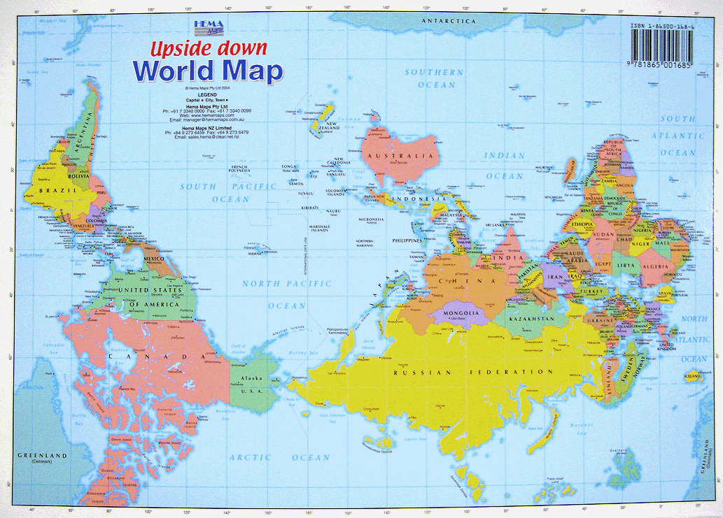
Subscribe to:
Posts (Atom)